Pathways and Physical accessibility
Why Display Accessibility Information?
Impacts a large percentage of the population: The World Health Organization estimates that 16% of people worldwide have a disability and that people with disabilities “find inaccessible and unaffordable transportation 15 times more difficult than for those without disabilities”. Persons with disabilities also have higher rates of acquiring new health conditions, partially due to reduced access to care and services.
It's important to them: Riders need up-to-date and accurate information about their transit options. Many agencies already use the General Transit Feed Specification (GTFS) to represent route, schedule, and stop location information that is critical to riders in planning their trips and understanding their options. For riders with accessibility needs, knowing the accessibility of a stop or vehicle is just as important as knowing the location. These riders need to know about every part of their trip to ensure they don’t get stranded somewhere or realize too late that they won’t be able to make it to their final stop.
It may be the law: Depending on your location, local or national law may require that you provide equal access and opportunity to people with disabilities. The following are some sources you may want to consider:
- United States: The Americans and Disabilities Act (ADA) and Section 504 of the Rehabilitation Act of 1973
- Japan: The Japan Ministry of Land, Infrastructure, Transport and Tourism Law for Promoting Easy Mobility and Accessibility for the Aged and Disabled (“Barrier-Free Law”)
- European Union: Employment, Social Affairs & Inclusion
Accessibility Checklist
The following are the steps needed to add accessibility information to your data. The next sections provide more detailed information on each step.
- Step 1: Add wheelchair accessibility information to
stops.txt - Step 2: Add wheelchair accessibility information to
trips.txt - Step 3: Add audio navigation information to
stops.txt - Step 4: Add physical accessibility information about transit stations with GTFS Pathways
Adding Wheelchair Accessibility in GTFS
You may already be familiar with the structure of GTFS as a series of .txt files. Wheelchair accessibility can be displayed by updating two fields: wheelchair_boarding in stops.txt and wheelchair_accessible in trips.txt.
Wheelchair accessibility in stops.txt
The field wheelchair_boarding in stops.txt allows you to indicate whether wheelchair boarding is possible from the specified location.
When this field is left empty, no accessibility information is displayed. This leaves riders unsure about accessibility and not able to tell if wheelchair boarding is actually not possible or if the information is just missing. Even if wheelchair boarding is not available, it is best to fill in that information to make it clear to riders and allow them to plan their trip with accurate information.
Wheelchair accessibility in trips.txt
The field wheelchair_accessible in trips.txt allows you to indicate whether the vehicle being used for a specific trip can accommodate a wheelchair.
Like wheelchair_boarding, when this field is left empty, no accessibility information is displayed. Even if the vehicle is not wheelchair accessible, it is still best to fill in that information to make it clear to riders and allow them to plan their trip with accurate information.
Adding Audio Navigation Aids
Text-to-speech is another way to increase the accessibility of your GTFS. Accurate text-to-speech information ensures that riders using assistive technology to read text aloud are getting the right information. This information can be included in your GTFS by updating tts_stop_name in stops.txt to correspond to each stop_name. Each stop within your GTFS should have a text-to-speech disambiguation that spells out the stop phonetically so it can be pronounced correctly.
While tts_stop_name is currently the only text-to-speech field officially adopted within the GTFS spec, other fields have been discussed and may be added. These include tts_agency_name, tts_route_short_name, tts_route_long_name, tts_trip_headsign, tts_trip_short_name, and tts_stop_headsign.
Riders will need to use an app that supports text-to-speech functionality, in order to benefit from this information. Some apps, such as NaviLensGo, are designed specifically to assist riders with vision impairments to navigate stations and find the right vehicle.
Adding Physical Accessibility Information about a Station
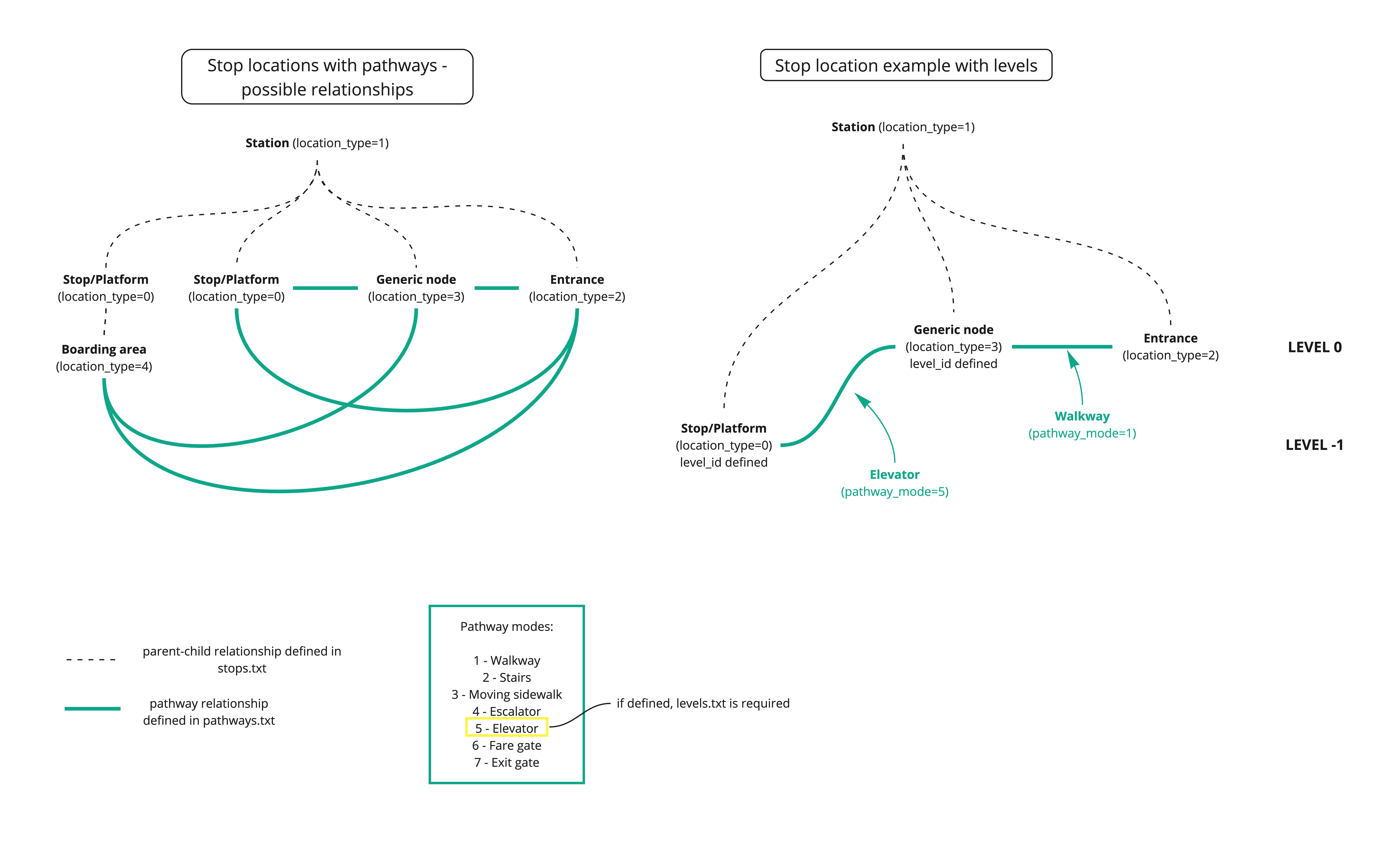
GTFS-Pathways is a component of GTFS that represents transit station details. It allows riders to understand whether they will be able to make a required transfer at a transit station.
GTFS-Pathways adds the files pathways.txt and levels.txt as well as adding the location_type field in stops.txt to link together the information described in pathways.txt.

Describe the location of station entrances and exits
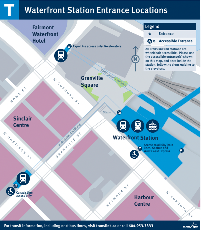
With GTFS, it is possible to accurately describe stations using information on entrances and station interiors. This example describes sections of Waterfront Station in downtown Vancouver. The station is part of the city’s Skytrain network and is served by the Canada Line, the Expo Line, the SeaBus, and the West Coast Express. Three street level entrances allow riders to enter and exit the station. The rest of the station is underground, with a concourse level for fare validation and a lower level with platforms.
First, the location of the station and its entrances are defined in stops.txt:
stop_id,stop_name,stop_lat,stop_lon,location_type,parent_station,wheelchair_boarding
12034,Waterfront Station,49.285687,-123.111773,1,,
90,Waterfront Station Stairs Entrance on Granville,49.285054,-123.114375,2,12034,2
91,Waterfront Station Escalator Entrance on Granville,49.285061,-123.114395,2,12034,2
92,Waterfront Station Elevator Entrance on Granville,49.285257,-123.114163,2,12034,1
93,Waterfront Station Entrance on Cordova,49.285607,-123.111993,2,12034,1
94,Waterfront Station Entrance on Howe,49.286898,-123.113367,2,12034,2
In the file above, the first record pertains to the station location, hence, the location_type is set to 1. The other five pertain to the three station entrances (five records are needed since the Granville entrance actually has three separate entrances, a stairway, an escalator, and an elevator). These five records are defined as entrances since the location_type is set to 2.
Additionally, the stop_id for Waterfront Station is listed under parent_station for the entrances to associate them with the station. The accessible entrances have wheelchair_boarding set to 1 and the non-accessible ones are set to 2.
Describe stairs and escalators
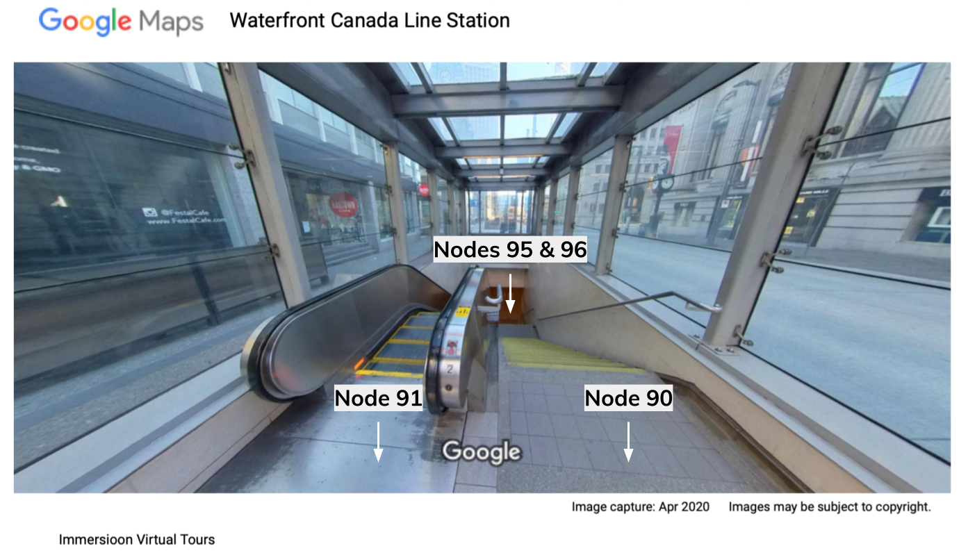
The entrance to Waterfront Station at Granville street has an elevator, an escalator, and stairs, the entrances are defined as nodes above in stops.txt. To connect the entrances to inner sections of the station, additional nodes have to be created in stops.txt under the parent_station of Waterfront Station. In the stops.txt file below, generic nodes (location_type 3) that correspond to the bottom of the staircase and escalator are defined.
stop_id,stop_name,stop_lat,stop_lon,location_type,parent_station,wheelchair_boarding
...
95,Waterfront Station Granville Stair Landing, 49.285169,-123.114198,3,12034,
96,Waterfront Station Granville Escalator Landing,49.285183,-123.114222,3,12034,

Next, the file pathways.txt is used to link nodes to create pathways, where the first record links the nodes pertaining to the top and bottom of the stairs. The pathway_mode is set to 2 to indicate stairs, and the last field describes that passengers can go both ways (up and down) on the stairs.
Similarly, the second record describes the escalator (pathway_mode set to 4). Since escalators can only move in one direction, the field is_bidirectional is set to 0, hence the escalator moves one way, from node 96 to 91 (upwards).
pathway_id,from_stop_id,to_stop_id_pathway_mode,is_bidirectional
stairsA,90,95,2,1
escalatorA,96,91,4,0
Describe elevators and pathways
The elevator at Granville street brings passengers to a pathway at the concourse level where the escalator and the stairs end. The elevator at the surface level is already defined as a station entrance above (stop_id 92). Hence, the elevator door at the concourse level also needs to be defined.
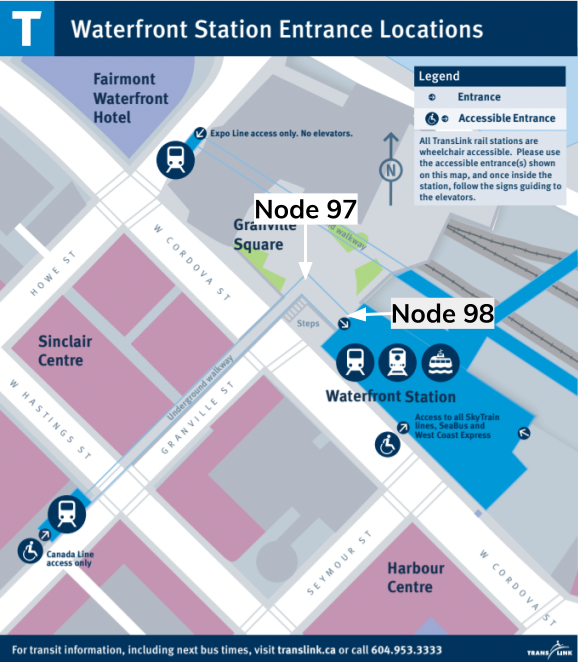
Additionally, as shown in the figure below, there is an underground walkway that connects the bottom of the stairs, escalator, and elevator at Granville street to the main station building. Therefore, two additional nodes are created to define the walkway sections.

stop_id,stop_name,stop_lat,stop_lon,location_type,parent_station,wheelchair_boarding
…
97,Underground walkway turn,49.286253,-123.112660,3,12034,
98,Underground walkway end,49.286106,-123.112428,3,12034,
99,Elevator_concourse,49.285257,-123.114163,3,12034,

Lastly, the nodes are connected together to define the underground pathway as shown in the file pathways.txt below:
pathway_id,from_stop_id,to_stop_id_pathway_mode,is_bidirectional
underground_walkway1,99,96,1,1
underground_walkway2,96,95,1,1
underground_walkway3,95,97,1,1
underground_walkway4,97,98,1,1
Future Additions to GTFS-Pathways
While the core specification of GTFS-Pathways has been completely integrated into GTFS, there is recognition that additional accessibility information could be modeled and would be useful to riders. This includes information such as text-to-speech instructions, wheelchair assistance information, equipment-failure reporting, planned or scheduled entrance or exit closures, and elevator and escalator outages. You can find more about the remaining parts of it in this document.